 Noreut
Google Maps in South Korea: What Works and How to Set Up Naver Map
Google Maps in South Korea finds places and shows transit routes, but walking and driving directions are still in preparation. Set up Naver Map in English.
- Published
- Updated

Illustration: a map pin, a subway train and a palace gate.
Install Naver Map before you go. As of November 20, 2026, Google Maps in South Korea finds places and shows public transit routes, but its walking and driving directions are limited. On November 17, The Korea Times reported that Google was still preparing to launch them.
| App | Place search | Transit directions | Walking directions | Driving navigation |
|---|---|---|---|---|
| Google Maps | Available | Available | In preparation | In preparation |
| Naver Map | Available | Available | Available | Available |
| KakaoMap | Available | Not confirmed | Not confirmed | Not confirmed |
Checked November 20, 2026. Google's status is from Edaily (November 13) and The Korea Times (November 17). Naver's status is from its help pages and store listings. KakaoMap's store listings describe route directions without naming each mode.
Why Google Maps lacks walking and driving directions
South Korea regulates the transfer of official map data abroad. Google said that routing on narrow city streets needs the 1:5,000 national base map, and that the coarser 1:25,000 map limits detailed directions (Google Korea Q&A).
On February 27, 2026, the government granted Google conditional permission to export certain 1:5,000 map data (Ministry of Land, Infrastructure and Transport). A South Korean partner must process the data on local servers. Exports are limited to the base map and road network data that navigation needs. Google must also protect imagery of military and other sensitive sites.
On November 13, a government committee reviewed how Google had met those conditions (government update). It confirmed limits on displaying Korean coordinates and a contract for a local partner to process and supply the data. The update lists local processing as a next step and says the government will keep monitoring the transfer abroad. None of these sources gives a confirmed launch date for walking or driving directions.
Naver Map or KakaoMap
Choose Naver Map if you need walking or driving directions. Its help pages document walking routes and public transit directions. Its store listing describes an English map and English navigation, including driving with live traffic. Business listings support English, and menus and descriptions can be machine translated.
KakaoMap's U.S. App Store listing offers English and Korean and describes place and bus stop search with route directions. It does not name walking or driving. KakaoMap needs iOS 18 or later. Naver Map needs iOS 16 or later, or Android 8 or later.
These are documented features only. They do not show how much of each screen appears in English.
Set Naver Map to English
Search your app store for NAVER Maps, Navigation by NAVER Corp. In the app, tap MY at the bottom of the home screen, tap the settings gear, then tap Language. If the app opens in Korean, look for 언어 (language).
- Android: choose English in the app's language menu.
- iPhone: the language setting opens the phone's settings for Naver Map. Under Preferred Language, choose English.
- iPhone, if the option is missing: go to Settings → General → Language & Region and add English to your preferred languages. Then return to Naver Map's language setting.
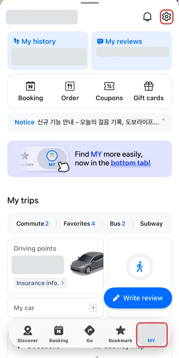
The MY tab, with the settings gear highlighted. NAVER Map app on an iPhone 14 Pro, captured November 20, 2026. Account details masked and highlights added.
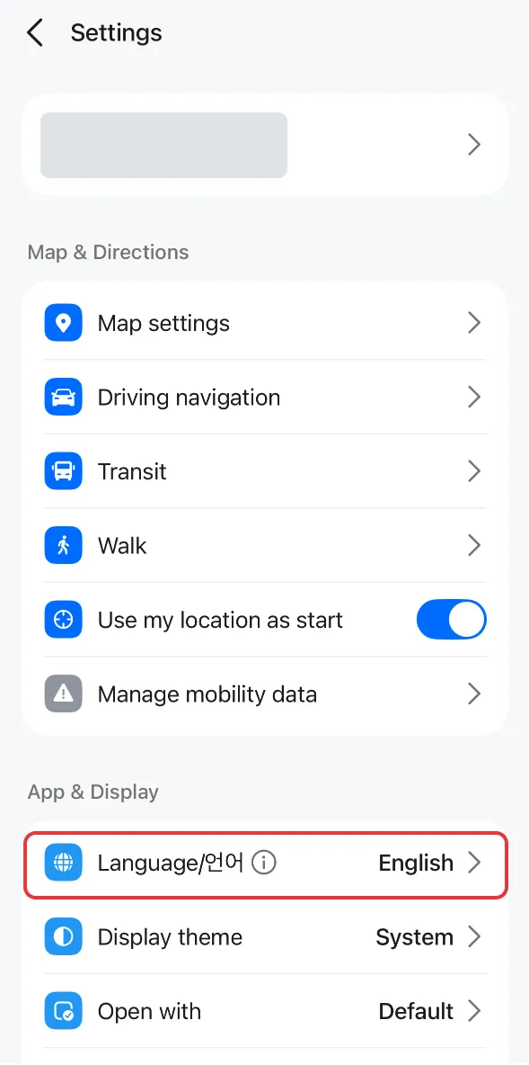
The Language row in Settings. NAVER Map app on an iPhone 14 Pro, captured November 20, 2026. Account details masked and highlights added.
Find a place by English name or Korean address
- Tap the search bar on the home screen and type the name from your itinerary, such as
Gyeongbokgung Palace. For a hotel or a café with several branches, add the neighborhood or the street address. - Compare the result's address and pin with your reservation or the venue's directions. The palace result may point to the grounds, one entrance, or the station named for it.
- If the result is wrong, paste the Korean name or address. The palace's Korean name is 경복궁. For other venues, the official page or your booking confirmation lists the road-name address (도로명주소).
- For the palace, the official access page gives
서울 종로구 사직로 161(161 Sajik-ro, Jongno-gu, Seoul). Copy the whole line and paste it into the search bar.

Geunjeongjeon Hall (근정전) at Gyeongbokgung Palace, photographed on October 24, 2008. Photo: Honza Soukup, licensed under CC BY 2.0. Resized.

Save the Korean address in a note that opens offline. If the venue's directions name an entrance, give it its own line. For a hotel, add the name from your reservation. You can show the note to staff if you need help finding the building.
Plan a public transit trip
- Tap the directions button near the upper right of the home screen.
- Enter a start and a destination. To plan from a hotel while you are still at home, enter the hotel as the start. If you leave the start empty, Naver uses your current location.
- Select Public transit. The all-modes view includes trips that combine buses and subways. Filters narrow it to bus or subway only, and you can sort by fewest transfers or least walking.
- Open a route. Naver shows the estimated time, fare and number of transfers, then each leg: the first stop, the bus number or subway line, where to change, and the final walk. The store listing also describes real-time departure and arrival information and alerts for boarding and getting off.
- For the palace, its directions list Exit 5 of Subway Line 3 at Gyeongbokgung Station (경복궁역) as one way in. On Korean signs, Exit 5 reads 5번 출구.
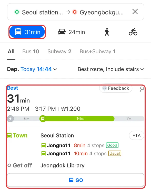
Public transit results from Seoul Station to Gyeongbokgung Palace at 2:44 p.m. on November 20, 2026. Times, fares and routes change. NAVER Map app on an iPhone 14 Pro, captured November 20, 2026. Account details masked and highlights added.
To preview the walk from a station, select Walking. Set the station or a landmark near the exit as the start and your hotel or venue as the destination. Naver's help says roads and crossings can change, so follow the signs and crossings you find.
If a screen is still in Korean, the labels are 길찾기 (directions), 대중교통 (public transit) and 도보 (walking).
Data and offline maps
Real-time transit information and live traffic use mobile data. Find out before you leave whether your plan includes data in South Korea.
For driving, download regional maps over Wi-Fi first. In Naver Map, go to MY → Settings → Navigation settings → Regional map downloads (권역별 지도 다운로드). The download reduces the data that driving navigation uses. Live traffic still uses data.
Google's Android help says offline downloads are not available in some countries and regions, and that offline maps do not give transit, cycling or walking directions.